-- New Jersey Geography (under construction)
* Home
|
Timeline
* Prehistoric-1699 * 1700-1749 * 1750-1799 * 1800-1849 * 1850-1899 * 1900-1949 * 1950-1999 * 2000- The state of New Jersey lies on the north eastern edge of the North American continent. Along the north, It shares a land border with the state of New York, a border whose delineation during colonial settlement was the subject of dispute and sporadic conflict in what was called the New York-New Jersey Line War, The border conflict was only resolved after King George III appointed a Royal commission to fix the line, a delineation ratified by both states and accepted by the King in 1773. eation until ratified by both states after the New York – New Jersey Line War, which is its only straight line border. New Jersey is slightly larger than the country of Kuwait.
The Atlantic Ocean is east of the state. It is separated from New York, in particular the boroughs of the Bronx and Manhattan in New York City by the Hudson River, and from Staten Island by the Kill van Kull and the Arthur Kill. Liberty Island is an exclave of State of New York in New Jersey waters in Upper New York Bay. Ellis Island, also in the Upper Bay, and Shooter's Island, in Newark Bay, each have sections belonging to either of the two states. On its west, New Jersey is flanked by the Delaware River that forms its border with the Commonwealth of Pennsylvania and Delaware Bay which separates New Jersey from the State of Delaware. However, due to a fluke in a colonial land grant for the city of New Castle, Delaware (called The Twelve-Mile Circle), there is a small amount of Delaware territory in contiguous New Jersey. Finns Point, piers at Penns Grove, New Jersey and Pennsville, and Artificial Island, the tip of a small peninsula at Lower Alloways Creek are connected to Salem County. A coal pier in Logan Township also extends into the river. New Jersey's natural regions were formed by glaciers. New Jersey is ranked 47th of the fifty states that comprise the United States of America in terms of area. The total area of the state is 8,729 square miles (22,610 km2), of which 14.9% or 1,304 square miles (3,380 km2) is water, and 85.1%, or 7,425 square miles (19,230 km2), is land. New Jersey spans 70 miles (110 km) at its widest, and 166 miles (267 km) in length.
Around 250 million years ago, during the Paleozoic and Mesozoic eras, the area that is today New Jersey bordered northern Africa as part of the supercontinent of Pangea. The pressure of the collision between North America and Africa gave rise to the Appalachian Mountains. Around 200 million years ago, Pangea began to break apart, separating the North American continent from the African continent. Around 18,000 years ago, the most recent ice age resulted in glaciers that reached New Jersey. As the glaciers retreated, they left behind Lake Passaic, as well as many rivers, swamps, and gorges. New Jersey's current geographic boundaries evolved in the years following the transfer in 1664 by the Dutch to the English of the territory which had comprised its colony of Nieuw Netherlands.
Within days of the bloodless transfer of New Netherlands from the Dutch to the English in 1664, the Duke of York’s new deputy governor Colonel Richard Nicolls was waited upon by a delegation of six men from towns in the Connecticut and Long Island representing an Association wishing to colonize lands in what was then known by the Dutch name Albania; shortly to be renamed New Jersey. The petition, dated September 26, 1664, sought permission to purchase from the Indians, Achter Kol, the name given to land west of the Achter Kull, the narrow channel separating Staten Island from the mainland. Governor Richard Nicolls immediately consented to the proposal and encouraged them in such good work. The purchasers bound themselves to pay the Indians, in two payments, wampum and goods, the equivalent of about 154 English pounds, for what became known as the Elizabethtown Purchase. The deed was signed by the representatives of the Associates and for the Indians Mattano and Seuakhenos. “By 1754, the feeling between the two factions had reached such a pitch that Governor Belcher of New Jersey wrote to His Majesty’s Lords of Trade in London that unless New York could be made to consent to the establishment of a temporary line of jurisdiction, ‘I expect no less than an actual war, by New York upon this province ... and I expect much bloodshed and Murders ...’”
On October 28, 1664 representatives of the Association, John Bailey Daniel Denton and Luke Watson and John Baker acting as interpreter, met in the wigwam of Mattano on Staten Island and purchased 500,000 acres of New Jersey (what is now Union, Somerset, Middlesex, Morris, Essex, Counties); land bounded by the Achter Kull, the Passaic River in the north, the Raritan River in the South, and extending to the west thirty-four miles
The Native New Jerseyans Evidence discovered along the Musconetcong River in Warren County confirms the presence of human inhabitants in New Jersey as long as 12,000 years ago. The more modern day native peoples known as the Lenape migrated from the west about 3000 years ago, to the area. The Lenape were part of the Algonquin language group. They were divided into three clans: the Minci in the north, the Unami in the central area and the Unilachtigo in the south of New Jersey. The Lenape were peaceable farmers, fisherman and hunters. They lived in scattered permanent villages where they planted crops. In the summer they moved to areas along the shore where they ate the abundant fish, clams, oysters and mussels. New Jersey possesses a moderate climate with warm, humid summers and relatively cold winters. The fourth-smallest state in the country, New Jersey's total land area covers 7,419 square miles; at its maximum, the state measures 170 miles from north to south, and 70 miles from east to west. Despite its modest size, climactic variations exist in different geographic regions of New Jersey, and various atmospheric and oceanic elements impact the state's climate.
The climate of New Jersey, like that of much of the United States, is dominated by the prevailing westerlies, an atmospheric conveyor belt on which weather systems travel from the western edge of the continent to the eastern edge of the continent. However, New Jersey's proximity to the Atlantic Ocean also affects the state's climate by moderating temperatures and providing abundant moisture for gathering storm systems. TemperaturesIn January, the coldest month, overall statewide highs average in the upper 30s and low 40s, with overnight lows bottoming out in the mid 20s. In July, the warmest month, statewide highs average in the mid 80s, with lows in the mid 60s. Spring and fall temperatures lie in between these two extremes, and are often mild and comfortable. For instance, October can still be quite pleasant, with an average high of 66 and an average low of 44. The warmest spot in New Jersey is Cape May, while the coolest is Sussex in the northern part of the state. PrecipitationPrecipitation in New Jersey averages 45 inches per year. The southeast coast receives the least amount of precipitation, around 40 inches, while the north-central region receives the most precipitation, nearly 51 inches. Measurable precipitation falls about 120 days each year, with autumn being the driest season. The driest location in New Jersey is Atlantic City, while the wettest is Morris Plains in the central part of the state. Thunderstorms occur in most locales approximately 25 to 30 times per year, with more storms near the coast than farther inland. Geographic VariationThe Appalachian Mountains rise to over 1,500 feet in the northwestern part of New Jersey. Hence, overall temperatures in this region are slightly colder than in the rest of the state, particularly during the winter --- for instance, freeze-free days in the highlands average only about 163 per year, whereas the central part of the state sees 179 days above freezing, and the coastline averages 217. These hills and mountains also receive more annual precipitation than the rest of the state, especially in the form of snow, which averages 40 to 50 inches per year. In contrast, only 10 to 15 inches of snow fall each year in New Jersey's extreme south. Along the state's long border with the Atlantic Ocean, onshore spring and summer breezes cool coastal communities, and can occasionally penetrate up to 40 miles inland. In autumn, the same areas remain warmer than the rest of the state, due to the nearby presence of the relatively warmer sea. 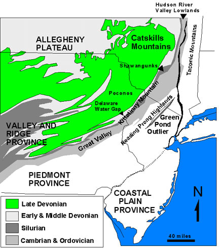
Map of the "Sedimentary Appalachians" Province in the New York Bight region including the Valley and Ridge Province and the Allegheny Plateau and the Catskill Mountains Image: US Geological Service
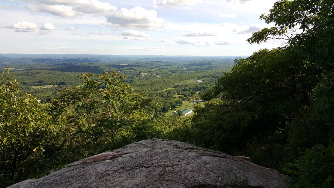
View from Sunrise Mointain of the Kittatinny Valley. Image: JackTheVicar at English Wikipedia, CC BY-SA 3.0
The New York–New Jersey Harbor Estuary, also known as the Hudson-Raritan Estuary, is in the northeastern states of New Jersey and New York on the East Coast of the United States. The system of waterways of the Port of New York and New Jersey forms one of the most intricate natural harbors in the world and one of the busiest ports of the United States. The harbor opens onto the New York Bight in the Atlantic Ocean to the southeast and Long Island Sound to the northeast.
Although the overall form of the estuary remains unchanged from the time of Giovanni da Verrazzano's visit in 1524, all parts have changed at least a little, and some parts, such as Hell Gate and Ellis Island, have been almost completely altered. In the greatest hidden change, the navigational channels have been deepened from the natural 17 feet (5.2 m) depth to 45 feet (14 m). In some places this required blasting of bedrock. There is an extremely complex system of tides and currents. Both the Bight and the Sound are essentially marine bodies with tides and saltwater, but the Sound compared to the Atlantic is about 20–30% less saline (as an estuary), and the tide is about 3 hours later with as much as 70% more variation. Rivers add a fresher, non-tidal inflow although the tide and brackishness extend well up rivers throughout the extended hydrologic system from Albany to Montauk Point to the Hudson Canyon region of the New York Bight. The New York Harbor Observing and Prediction System (NYHOPS) utilizes information from sensors, weather forecasts, and environment models to provide real-time forecasts of meteorological and oceanographic conditions in the area. With the exception of the 50-mile northern boundary from the Hudson
River to the Delaware River, separating it from New York, the State is entirely surrounded by water, 300 miles of which are navigable. It is bounded west and south by the Delaware River and the Delaware Bay, dividing it from Pennsylvania and Delaware. On the east it is bounded by the Atlantic Ocean, the Hudson River, Arthur Kill, Kill van Kull, and New York Bay, which separate it from New York. The State falls naturally into three physical divisions of sharply differentiated scenery: 1) the Appalachian Highlands In the north, a mountainous, lake-studded region; 2) the Triassic section in the central part, featuring gently rolling hills; and 3) the Coastal Plain in the southern region of the Pinelands and shoreline and beaches. Along the northwest border are the level-topped narrow Kittatinny Mountains, which at High Point above the Delaware River mark the highest elevation in the State at 1,805 feet above sea level. The mountains, whose name comes from a Lenape Native American word meaning "endless hill" or "great mountain," are part of the Appalachians which continue on the East Coast from Maine to Georgia. Around four hundred fifty million years ago, a chain of volcanic islands shaped like an arch collided with proto North America. The North American plate went under the chain of islands. The islands went on top of the edge of North America creating the Highlands and the Kittatinny Valley which is the Ordovician Martinsburg Shale. Quartz and other sedimentary conglomerate was transported to the inland sea, which was over part of the Martinsburg Shale. A small continent then collided with North America around four hundred million years ago. Geologic pressure resulted, which caused compression and then folding and faulting resulted. The folding ran perpendicular to the directional forces. During folding, intense heat melted silica which cemented the quartz and other stones together. Also the intense heat allowed the rock layers to bend, thus the Kittatinny Mountain was born. Bisecting the Kittatinnys in New Jersey is the Delaware Water Gap, 900 feet wide at the base and 4,500 feet wide at the top, with sides rising to a height of 1,200 feet or more. The Green Pond Outlier is a complex northeast-trending belt of Paleozoic sedimentary rocks that bisects the Precambrian crystalline rocks of the Highlands Province, and extends for 65 miles between I-80 in New Jersey and the New York Thruway in New York. The sedimentary rocks within this belt are folded into a formation in which the beds are locally completely overturned, The trough is locally broken by faults that run in parallel to the axis of this great fold, locally giving it a graben-like character in portions of the New Jersey region. The New Jersey Highlands are part of the great sweep of the Appalachians that shadow the East Coast from Maine to Georgia. The region contains nearly 860,000 acres of forested ridges, rolling farmlands, diverse recreational opportunities, abundant wildlife and significant historic and scenic resources. New Jersey’s Highlands, a similar band which begins in Connecticut, crossing into New York State and then passing through New Jersey before entering Pennsylvania. In New Jersey, the Highlands stretch about 60 miles, from Oakland in the northeast at the New York border to Phillipsburg at the Delaware River, where they then continue southwest through Pennsylvania west of Philadelphia..They lie within portions of seven northwest New Jersey counties — Bergen, Hunterdon, Morris, Passaic, Somerset, Sussex, and Warren — and include 88 municipalities within the legislated region. To the east of the Kittatinny Mountain, is the Great Kittatinny Valley. This is drained by the Paulinskill River in the south and the Wallkill River in the north. The Big Flatbrook drains the mountain on the northwestern end beginning at Steam mill swamp and flows in a southwesterly direction which drains into the Delaware River near Flatbrookville, an area known as the Flatbrook Valley. The Port Jervis trough is at the northwestern end of the mountain. The Delaware River flows near the mountain at the south end, finally cutting across the ridge at the Delaware Water Gap just south of Mount Tammany. The Kittatinnies are a far northeastern extension of the Ridge and Valley province of the Appalachian Mountains. Between the Kittatinny Mountains on the west and the High lands on the southeast is Kittatinny Valley. Several parallel ridges, remarkably uniform in height, and some of the oldest rocks in America, form the lesser elevations. Among the best-known are the Green Pond, Schooley, Hopatcong, and Jenny Jump; between them, lakes, swamps, brooks and narrow valleys are frequent. Summer resorts and large country estates are situated throughout this region. To the south lies cleared land used for agriculture. The Highlands do not end at the State line but stretch northeasterly to West Point, where they become the Highlands of the Hudson, and southwestward into Pennsylvania. Elevations in this area average about 800 feet. Lake Hopatcong, in the south central section of the Appalachian Highlands district, is the largest inland body of water wholly within the State. It has an area of 2,443 acres and a shoreline of more than 40 miles. Greenwood Lake, with 1,290 acres, is divided between New Jersey and New York. Nearby is Wanaque Reservoir, the State's largest artificial lake. Scores of smaller lakes, many of glacial origin, are found in this region. One-fifth of the State, a long strip barely 20 miles wide, the city belt of New Jersey, lies within the Triassic Lowland division, which extends from Delaware River to Hudson River, and north from US i (the straight-line highway between Newark and Trenton) to the base of the Ramapo Mountains. |
|
|
|
.